
Is it a surprise that this summer clocked the nation’s third hottest July on record? We bet you’re tired of riding in the unrelenting summer heat. Roasting at sun-drenched rallies, speeding along asphalt that seems to sizzle, vented gear and hydro-cooling vests barely helping at all, sweat dripping in all the wrong places, and distressingly swampy spots forming in “unmentionable” nether regions. Whew.
Fall is now in our sights, though, and you deserve some epic riding in cooler mountain temps!
Because attendees loved it so much in 2021, the 2022 BMW Riders Association’s National Rally is in the heart of the Smokies once again—but this is the LAST YEAR to gather there with your RA pals. Choose gently curving or tight-and-twisty routes lined with breathtaking scenery and plenty of trees for shade. Carve those corners in crisp, high-elevation air. Hop on the Blue Ridge Parkway, the famous scenic tour that boasts 469 miles without a traffic signal. Discover why so many riders—from beginners to experts—believe Western NC contains the greatest motorcycle rides in the nation.
As a bonus, catch the magic of changing foliage colors by heading to the highest elevations. In the last week of September, spotty color typically begins at 6,000+ feet in the highest mountains and on high rocky ridges. In the first week of October, color may begin to transform above 5,000+ feet.
Here’s your guide to amazing rides, whether on paved, unpaved, or hybrid terrain; fuel/food stops; and points of interest in the Western NC area convenient to the rally.
Jump to…
RIDES
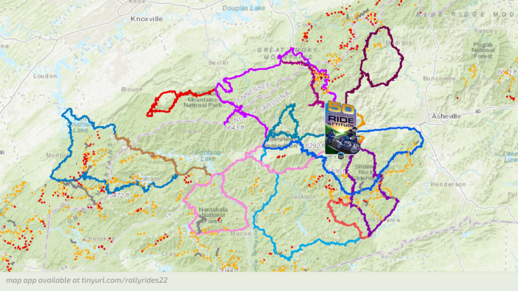
The BMW Riders Association’s 2022 National Rally is the perfect base to explore the breathtaking scenery and homegrown hospitality of the North Carolina Smoky Mountains. Every year, the area’s winding roads draw thousands of motorcycle riding enthusiasts in search of the best scenic twists and turns.
The “Rally Rides” are suggested routes that informal groups may follow—GPX files and PDF map downloads make it easy to explore at your own pace and at times most convenient for you and your friends. PRO TIP: Make new friends at the hot dogs & beer event Thursday evening, Sept 29!
Want maps? There are lots of options!
- Bookmark this app on your mobile device—it contains most of the info and maps in this article.
- Download a GPX file of most routes in this article. The download will begin immediately and may take a few moments, so please be patient. You may also download the files individually; see ride descriptions below.
- Download a 6-pg PDF brochure describing 8 popular motorcycle routes in the NC Smokies (Haywood County).
- Download a 13-pg PDF brochure describing 12 popular motorcycle routes in the NC Smokies (Haywood County).
From novice riders to seasoned motorcyclists, there are routes appropriate for all skill levels. We’ve compiled our favorites in this article and labeled each with a difficulty level:
EASY is for beginning motorcyclists and features gradual grades and gentle curves.
MODERATE is for intermediate riders and features steeper grades and tighter curves.
CHALLENGING is for advanced riders and features steep grades and sharp, technical curves.
Annnnnd here we go! ENJOY!
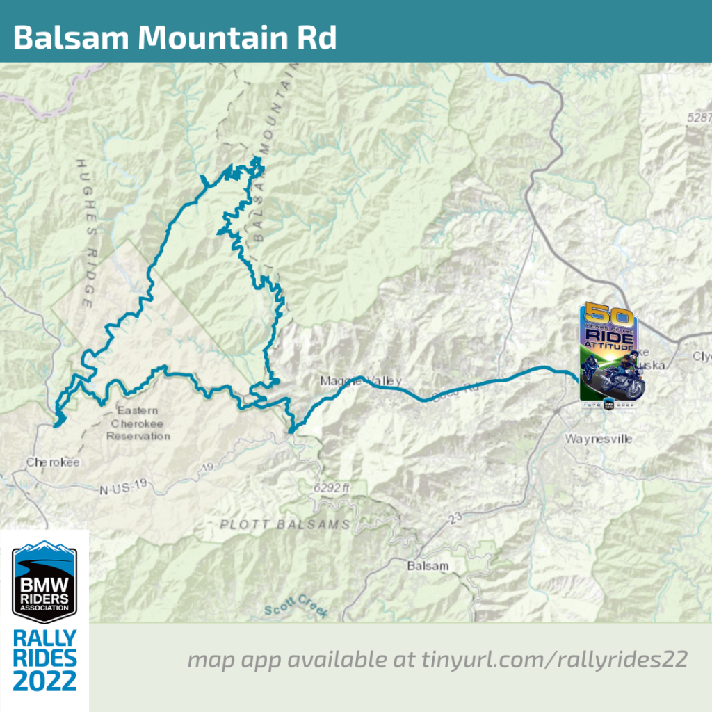
Balsam Mountain Rd
Difficulty: Moderate to challenging with tight spots
Terrain: off-road
Length: approximately 80 miles / 3 hours
Downloads: GPX file | PDF map
The route from the rally features paved and unpaved portions, but all of Balsam Mountain Road is unpaved (gravel). This is a great option if you’re looking for a dual-sport escape from the traffic on the more heavily-traveled roads in the Great Smoky Mountains National Park. more info
Points of Interest
…see descriptions in the alphabetized list here.
- Heintooga Overlook
- Mingo Falls
Best of the Blue Ridge Parkway
Difficulty: Easy
Terrain: on-road
Length: approximately 50 miles / 4 hours
Downloads: GPX file | PDF map
This is an easy minimum 1/2 day ride. Arcing along the peaks on Haywood County’s southern border, enjoy the highest and most scenic portion of the BRP. Enjoy the views! more info
Points of Interest
…see descriptions in the alphabetized list here.
- Waterrock Knob (milepost 452.3)
- Woodfin Cascades Overlook (milepost 446.7)
- Highest Point on the Blue Ridge Parkway (milepost 431.4)
- Devil’s Courthouse Overlook (milepost 422.4)
- Looking Glass Rock Overlook (milepost 417)

Cades Cove and Rich Mountain Rd
Difficulty: Challenging
Terrain: on-road with off-road option
Length: 150 – 180 miles / all day
Downloads: GPX file | PDF map
Cades Cove is a broad, verdant valley surrounded by mountains and is one of the most popular destinations in the Great Smokies. It offers great opportunities for wildlife viewing—large numbers of white-tailed deer are frequently seen, and sightings of black bear, coyote, groundhog, turkey, raccoon, skunk, and other animals are also possible. From the rally, take US 441 via Fighting Creek Gap Road, Little River Gorge Road and Laurel Creek Road (all paved).
Touring the Cove: An 11-mile, one-way paved loop road circles the cove, offering motorists the opportunity to sightsee at a leisurely pace. Allow at least two to four hours to tour Cades Cove, longer if you walk some of the area’s trails. Traffic will be heavy. While driving the loop road, please be courteous to other visitors and use pullouts when stopping to enjoy the scenery or view wildlife. more info
You may return to the rally the way you came or get off the beaten path by taking the gravel surfaced Rich Mountain Road which heads north from Cades Cove over Rich Mountain to Tuckaleechee Cove and Townsend, TN. The 8-mile, one-way gravel road provides beautiful views of Cades Cove. Many prize-winning photographs come from here. Situated on a dry ridge, an oak-dominated forest lines the roadside. Once outside the national park, the road becomes steep and winding.
From Townsend, you can reenter the park via the Townsend Entrance Road, turn west to hit the Tail of the Dragon, or go east on US 321 toward Gatlinburg.

Copperhead Loop
Difficulty: Moderate to Challenging
Terrain: on-road
Length: approximately 98 miles / 3 hours
Downloads: GPX file | PDF map | Google Maps link
This is a moderate 3 hr ride, more with stops. US 276 and NC 215 are two of the finest motorcycle rides you’ll find. The Copperhead Loop links them using US 64 through Brevard. You’ll enjoy wonderfully twisty roads, waterfalls, and intersect the Blue Ridge Parkway at two points. Make a short loop or an all day adventure exploring several waterfalls! more info
Points of Interest
…see descriptions in the alphabetized list here.
- Pisgah National Forest
- Cradle of Forestry
- Sliding Rock
- Looking Glass Falls
- Pisgah Astronomical Research Institute
- Sunburst Falls
- Lake Logan

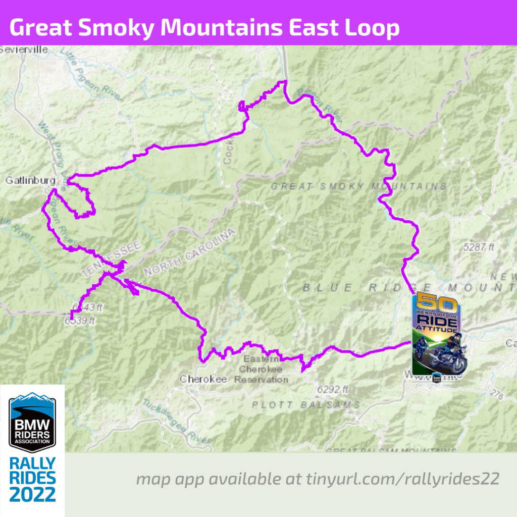
Great Smoky Mountains National Park East Loop and Roaring Fork Motor Trail
Difficulty: Easy
Terrain: on-road
Length: approximately 150 miles / 6 hours
Downloads: GPX file | PDF map
An easy 4-6 hr ride. Don’t pass up a chance to see the sights of Great Smoky Mountains National Park. Better yet, entry into the National Park is completely free! This ride loops the east side of the park. Plan extra time during peak season.
Points of Interest
This route includes two side trips worth considering (see descriptions in the alphabetized list here):
- Clingmans Dome
- Roaring Fork Motor Trail (including Rainbow Falls, Grotto Falls, Place of a Thousand Drips)
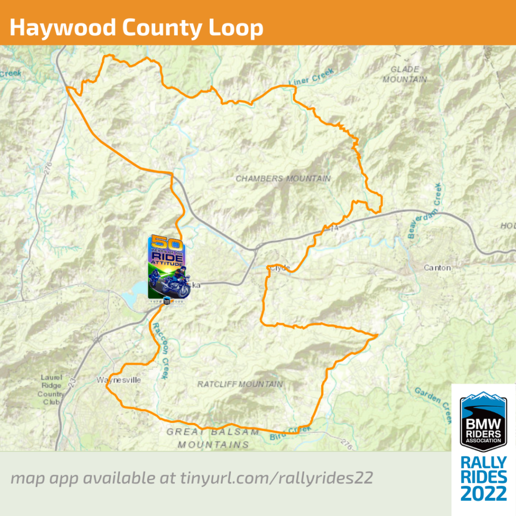
Haywood County Loop
Difficulty: Challenging
Terrain: on-road
Length: approximately 45 miles / 2 hours
Downloads: GPX file | PDF map
This is a difficult 1.5 – 2 hr ride. One of the many ways to loop ride some of the best roads that Haywood County offers and never be far from where you lay your head. Don’t take it lightly, these roads are as challenging as you’ll find. This is a great loop for the “iffy” days when you might want to stay close to home. more info
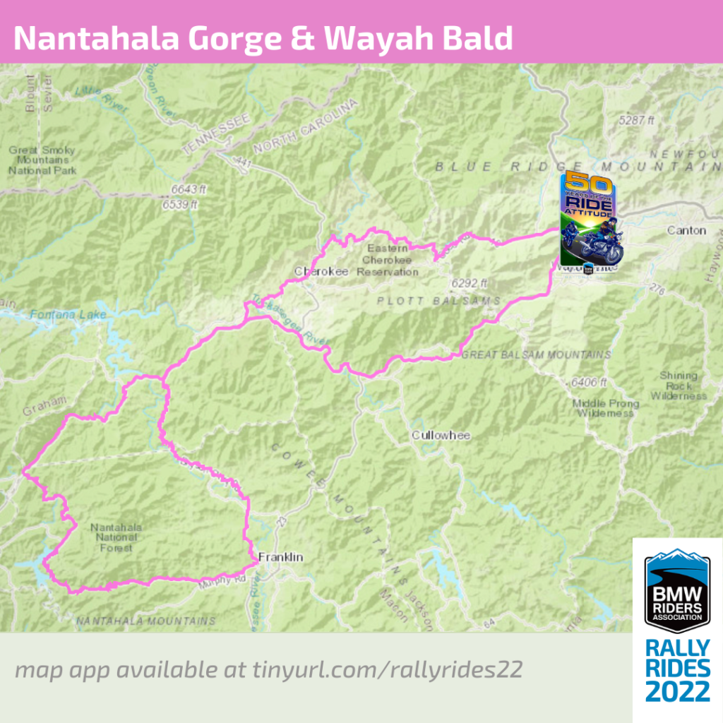
Nantahala Gorge and Wayah Bald
Difficulty: Challenging
Terrain: on-road
Length: approximately 155 miles / 6 hours
Downloads: GPX file | PDF map
A difficult 4-6 hr ride. Nantahala Gorge is known for whitewater rafting and stunning scenery. Climb to the river’s alpine source, then cross Wayah Bald on a ride everyone loves. Complete your loop with a ride on one of North Carolina’s best curvy roads.
Old Cataloochee Turnpike, Mt Sterling Rd, and TN 32
Difficulty: Moderate to challenging
Terrain: on-road and off-road
Length: about 90 miles / 3 hours
Downloads: GPX file | PDF map
The ride to Cataloochee from the rally is a mixture of pavement and gravel with some tight turns and steep grades. Start your day bright and early with a visit to see the reintroduced elk of Cataloochee Valley, which are most visible during dawn and dusk. The valley is one the most remote parts of the Great Smoky Mountains National Park and is rich in mountain history, wildlife, and beauty. With several hiking trails, streams for fishing, and preserved buildings from the early 1900’s, there is plenty to explore.
After visiting the valley, continue north on the Old Cataloochee Turnpike. About 8.5 miles north of Cataloochee Valley, Old Cataloochee Turnpike changes its name to Mt Sterling Rd and about 5.25 miles beyond that, at the Tennessee border, it becomes TN 32. From there it’s another 11 miles to Cosby, TN. more info
From Cosby, you can return to the rally by taking the Foothills Parkway to I-40 or head west on US 321 into Gatlinburg for a bite to eat.
For those not wishing to go all the way to Cosby there are several shortcut options:
- At the point where Old Cataloochee Turnpike becomes Mt Sterling Rd, Forest Service Rd 288 (Buzzard Roost Rd) comes in on the east side of the turnpike. This is a gravel surface road that winds for about 11.5 miles through the Pisgah National Forest to I-40, with an optional 1.5-mile side jaunt up Sutton Tower Rd to the top of Longarm Mountain, (elev 3624 ft). Download GPX file or Download PDF
- About 14 miles north of Cataloochee Valley (or about 5.25 miles beyond Forest Service Rd 288), Forest Service Rd 289 (Old Buzzard Roost Rd) heads off to the east. This is a 4-mile gravel road that T’s into Buzzard Roost Rd. Turning right on Buzzard Roost will return you to Old Cataloochee Turnpike. Turn left (northeast) on Buzzard Roost to ride the remaining 6.5 miles to I-40. Going this way, after only about 150 ft northeast from the intersection, you’ll find the turnoff for Sutton Tower Rd up Longarm Mountain. Download GPX file or Download PDF
- One mile beyond Old Buzzard Roost Rd, just after crossing Big Creek, Mt Sterling Rd intersects with Waterville Rd, for 2 miles of pavement to I-40. Download GPX file or Download PDF
- A mile farther on is the Tennessee border where Mt Sterling Rd becomes TN 32, and 2.6 miles beyond that, Tobes Creek Rd turns off to the east. This is a steep, winding gravel surface road that meets I-40 at the same place as Waterville Rd. Download GPX file or Download PDF

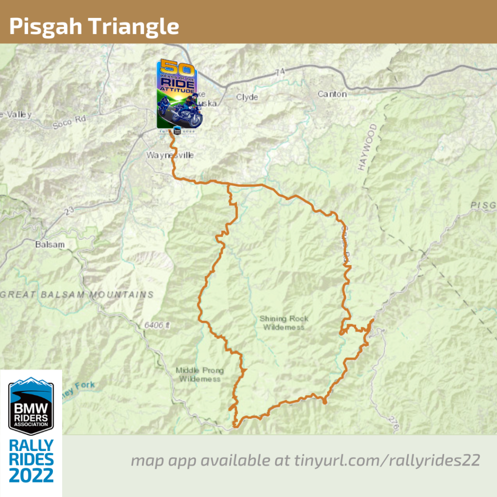
Pisgah Triangle
Difficulty: Moderate
Terrain: on-road
Length: approximately 50 miles / 2-3 hours or more
Downloads: GPX file | PDF map
The Pisgah Triangle will have you experiencing the best of the Blue Ridge. While up on the parkway you can stop at the Looking Glass Rock Overlook for a view of this pluton monolith. If time allows, head across the street to hike down to Skinny Dip Falls. Further down the parkway is the Graveyard Fields area which includes restrooms, hiking and two waterfalls. Just past there you can visit the Black Balsam Knob. Finally, stop at the Devil’s Courthouse Overlook to take in the sights. If you are up for a short-but-steep hike, you can quickly make your way to the top of the rock! On the way back down NC 215, enjoy sweeping turns, roadside waterfalls, and eventually Lake Logan. more info
Points of Interest
…see descriptions in the alphabetized list here.
- Pisgah National Forest
- Looking Glass Rock
- Skinny Dip Falls
- Graveyard Fields
- Black Balsam Knob
- Devil’s Courthouse Overlook
- Lake Logan
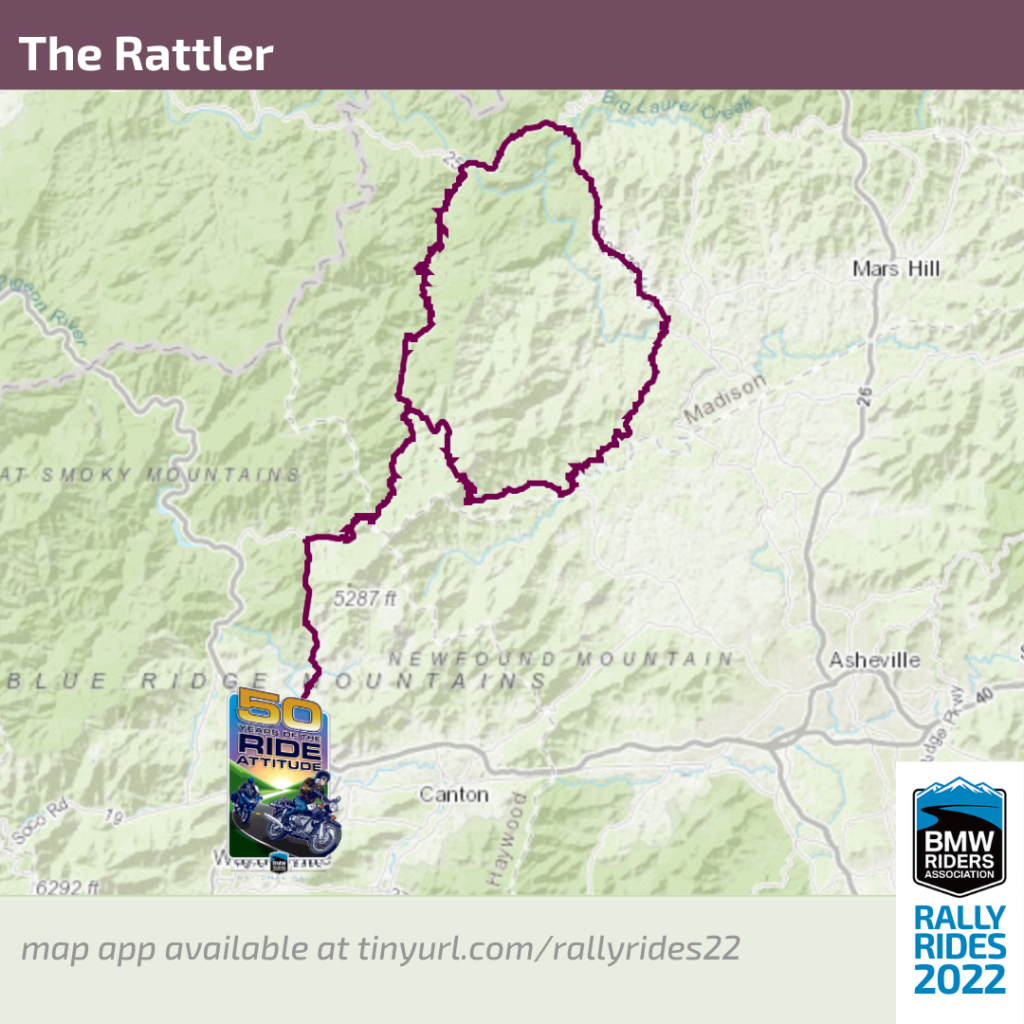
The Rattler
Difficulty: Challenging
Terrain: on-road
Length: approximately 30 miles / 1 hour
Downloads: GPX file | PDF map
A difficult 1 hr ride to Hot Springs or a 1/2 day loop (98 miles). 290 curves in 24 miles, this out-and-back ride is a longtime favorite among locals. NC 209 takes you on a challenging and scenic 30-mile ride north to Hot Springs. Return the same way or extend your ride and make it a 100-mile loop! more info
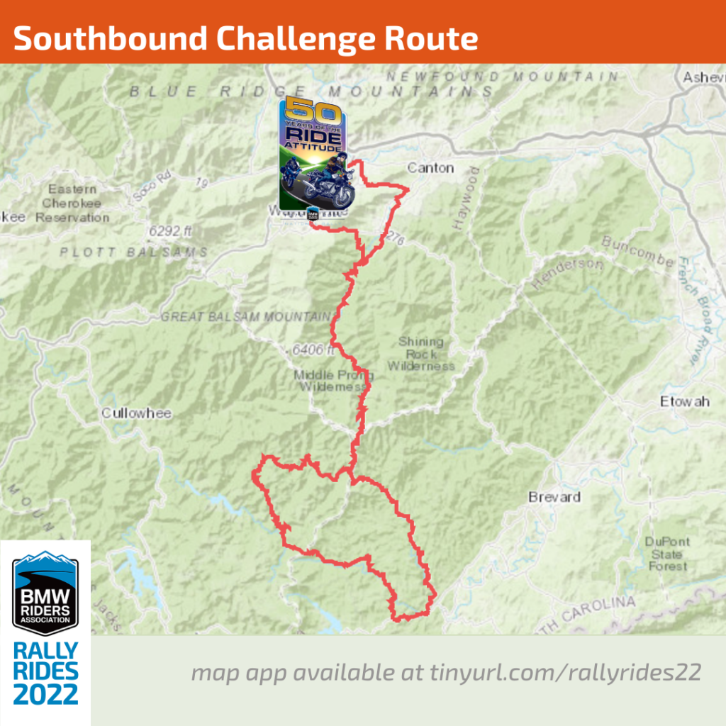
Southbound Challenge (“Some Challenging Roads”)
Difficulty: Challenging
Terrain: on-road
Length: 90 miles / 3-4 hours
Downloads: GPX file | PDF map
This is a challenging route south of the Rally with a little of everything: twisties, ups and downs, sweepers and straights but also potholes, patches, loose gravel and animals (both wild and domestic) in the road. Ride this with care as it has some very tricky and technical portions that will demand your attention.
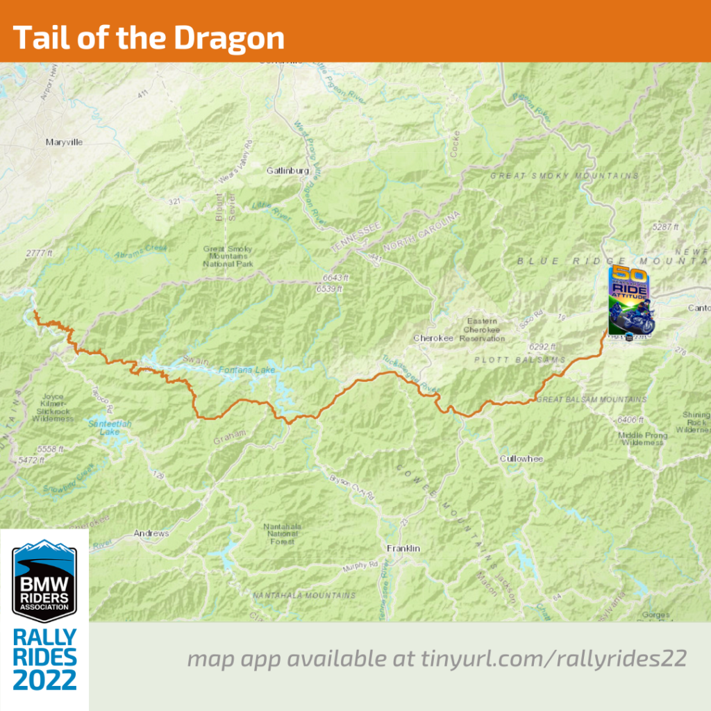
Tail of the Dragon
Difficulty: Challenging
Terrain: on-road
Length: approximately 160 miles / 4 hours
Downloads: GPX file | PDF map
Approximately 80 miles each way for a total round trip of 160 miles, this is an iconic 2-hr ride (4 hours total) to Deals Gap. The Tail of the Dragon has 318 curves in 11 miles, and is America’s #1 motorcycle and sports car road. more info
PHOTO OPS: Many photographers such as killboy.com, 129slayer.com, and 129photos.com set up along this famous road to snap shots of motorcycles and other vehicles that pass by. Check these sites after your ride to see if they captured you!
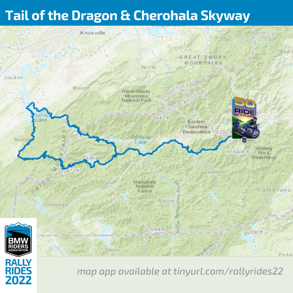
Tail of the Dragon and Cherohala Skyway Loop
Difficulty: Challenging
Terrain: on-road
Length: approximately 250 miles / 8 hours
Downloads: GPX file | PDF map
An all-day loop combining the Tail of the Dragon, with its 318 curves in 11 miles, with nearby Cherohala Skyway featuring 60 miles of breathtaking mountain scenery. more info
PHOTO OPS: Many photographers such as killboy.com, 129slayer.com, and 129photos.com set up along this famous road to snap shots of motorcycles and other vehicles that pass by. Check these sites after your ride to see if they captured you!
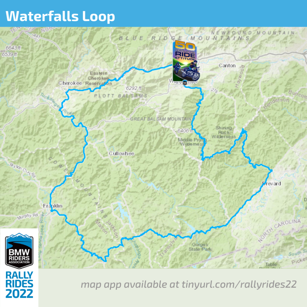
Waterfalls Loop
Difficulty: Easy
Terrain: on-road
Length: approximately 190 miles / 8 hours
Downloads: GPX file | PDF map
An easy all-day ride. Tour more than a dozen roadside waterfalls on this long and scenic drive. Break the Loop into 2 days if you’d like to make more stops along the Parkway and mountain towns. more info
Waterfalls
…some descriptions in the alphabetized list here.
*not visible from road
- Soco Falls* – Gravel pull-off on left. Follow path.
- Cullasaja Falls – Limited and hazardous parking near guardrail on curve.
- Quarry Falls – Paved pull-off on right side of road.
- Dry Falls* – Paved parking on right. Short trail to waterfall. $3 parking/access fee; hours are dawn to dusk. more info
- Bridal Veil Falls – Paved pull-off. Drive behind waterfall for photo.
- Toxaway Falls – Paved pull-off on dam side.
- Looking Glass Falls – Paved parking on right. Boardwalk to falls.
- Moore Cove Falls – Trail head on the right and a .7 mile hike to the falls.
- Sliding Rock – Parking lot leads to walkway for falls. $3 parking/access fee; hours: 10:00am-6:00pm from Memorial Day to Labor Day; lifeguards on duty and restrooms open when fee is charged. more info
- Skinny Dip Falls – Pull-off near BRP mile marker 417; a moderate, short hike to the falls.
- Second Falls* – Pull-off on right at Graveyard Fields overlook. Trail on right.
- Upper Falls – One of several falls accessible from the Graveyard Fields Overlook on the BRP.
- Bubbling Springs Falls* – Dirt pull-off 1.8mi from BRP.
- Sunburst Falls – Parking spots along either side of the bridge or 0.25 mi up or down from the falls
FOOD+FUEL
Your body needs food, your bike needs fuel and your phone needs cell service. The first two are widely available throughout the region but the third one may not be. So download a GPX file of food and fuel stops near these great routes and load it into your GPS for those times when you need a bite or a gallon and can’t get a signal.
Gas stations marked with an asterisk advertise ethanol-free gas.
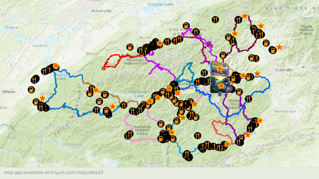
POINTS OF INTEREST
Like your rides with a side of sightseeing, history, or culture? We’ve got you!
- Bascom Visual Arts Center. You’re bound to find yourself passing through Highlands, NC as so many good roads converge here. Leaving town, heading west towards the waterfalls, watch for the Stevens Covered Bridge. A short ride across the bridge brings you to the Bascom Art Center featuring crafts, pottery, glassworks, and a nice gallery. It’s a quick loop through to see the wood pegged covered bridge or spend an hour touring the facility and browsing the wares.
- Black Balsam Knob
- Blue Ridge Parkway. America’s favorite scenic road even has its own app. Access a handy list of overlooks here.
- Blue Ridge Parkway Highest Point (milepost 431.4): Long range views and photo op with the iconic sign.
- Brasstown Bald in Georgia is a little more than an hour away. The Brasstown Bald Visitors Center sits atop Georgia’s highest mountain at 4,784 feet above sea level, and its cloud-level observation deck offers stunning 360-degree views of the Southern Appalachian Mountains and valleys. On a clear day, you can see four states.
- Cherohala Skyway
- Clingmans Dome – At 6,643 feet, this is the highest point in the Great Smoky Mountains National Park. It is the highest point in Tennessee, and the third highest mountain east of the Mississippi. Only Mt. Mitchell (6,684 feet) and Mt. Craig (6,647), both located in Mt. Mitchell State Park in western North Carolina, rise higher. The observation tower on the summit offers spectacular 360° views for visitors willing to tackle the steep half-mile walk to the top.
- Cradle of Forestry (National Park Service). more info
- Devil’s Courthouse (milepost 422.4 on the Blue Ridge Parkway): Impressive rock formation with long range views.
- Fontana Dam. While the area is rich with falling waters there is also a plethora of dams holding the waters back and forming many beautiful mountain lakes. A visit to the largest of them, the Fontana Dam, is a worthwhile stop. It’s the highest dam in the east and both the top and bottom are accessible. The visitor center and viewpoints are at the top of the dam, and you should certainly make the drive across it and back. The road leading out to the bottom of the dam is located just across the bridge beyond Fontana Village on NC 28 and leads out to the powerhouse. If a rare water release is occurring during your visit, rush out here to see it! The plumes shoot 400 feet across the river and 150 feet up into the air. It’s quite a sight!
- Graveyard Fields. Named for the haunting skeletons of ancient trees punctuating an otherwise grassy field, this Blue Ridge Parkway overlook offers a breathtaking view.
- Grotto Falls
- Heintooga Overlook
- Lake Logan
- Looking Glass Falls
- Looking Glass Rock Overlook (milepost 417 on the Blue Ridge Parkway): Best view of the granite dome.
- Mingo Falls, one of the tallest and most spectacular waterfalls in the southern Appalachians. Near the end of the Balsam Mountain ride, before you reach the Blue Ridge Parkway, stop off at Mingo Falls for a break. The moderate hike to the waterfall is only 0.4 miles in length. It is on the Cherokee Indian Reservation just outside Great Smoky Mountains National Park. No special permits are required for access to the reservation.
- Mount Le Conte, the highest in Tennessee, is in Great Smoky Mountains National Park. Follow the spur road seven miles out from the top of the climb at Newfound Gap on US 441.
- Mount Mitchell is the highest mountain in the east and just a couple of hours cruise up the Blue Ridge Parkway.
- Nantahala Gorge
- Oconaluftee Visitor Center. Great Smoky Mountains National Park has had great success re-introducing elk to the parklands and you can reliably count on seeing them. One of the larger herds spends a lot of time around the Oconaluftee Visitor Center. It’s an easy ride—just follow the Blue Ridge Parkway to its south end and turn right.
- Pisgah Astronomical Research Institute. Hidden away in the forest near Brevard, PARI is a unique place with its large radio telescopes. Located off Macedonia Church Road, it’s not open to the general public, but it can be a quick stop to grab a photo. Visit their website in advance to schedule a private tour of the space exhibits and museum.
- Pisgah National Forest
- Place of a Thousand Drips
- Rainbow Falls
- Rich Mountain Road
- Road to Nowhere. Yet another unique experience in the area is The Road To Nowhere. Part of Great Smoky Mountains National Park, the abandoned project is found north of Bryson City. A parkway-like road leads seven miles out along Fontana Lake to end abruptly at a long tunnel. Park here and take the stroll through the cool dark passage to reach the foot trails leading into the forest at the other side. While in Bryson City don’t miss the Great Smoky Mountains Railroad and enjoy numerous good places to get a bite to eat.
- Roaring Fork Motor Trail – Roaring Fork is one of the larger and faster flowing mountain streams in the area. The narrow, winding, Roaring Fork Motor Nature Trail invites you to slow down and enjoy the forest and historic buildings of the area. The 5.5-mile-long one-way loop road offers rushing mountain streams, glimpses of old-growth forest, and a number of well-preserved log cabins, grist mills, and other historic buildings. The entrance to the motor nature trail is located a short distance past the parking areas for Rainbow Falls. The trailhead for Grotto Falls, another of the park’s most popular waterfalls, is located along the route. And a “wet weather” waterfall called Place of a Thousand Drips provides a splendid finale to your journey. An inexpensive booklet available at the beginning of the motor nature trail details landmarks along the route.
- Sassafras Mountain, the highest peak in South Carolina. It’s a great ride down on NC 215, one of our finest local roads. You then wind back into the forest to reach the small park and observation tower. Good roads, no crowds, and a unique location make this mountain top worth the visit.
- Skinny Dip Falls
- Sliding Rock
- Stevens Covered Bridge. Heading west from Highlands, NC, watch for the iconic wood pegged covered bridge. The short ride across it brings you to the Bascom Art Center featuring crafts, pottery, glassworks, and a nice gallery.
- Sunburst Falls
- Tuckaleechee Cove
- Visit NC Smokies, the Haywood County visitors center with maps, guides, gift shop, and restrooms. Swing by as you pass through Maggie Valley.
- Waterrock Knob (milepost 452.3 on the Blue Ridge Parkway): Stop by this Blue Ridge Parkway Visitor Center and enjoy long range views from the parking lot.
- Wayah Bald
- Wheels Through Time Museum, an all-American motorcycle showplace in Maggie Valley. Swing by as you pass through Maggie Valley.
- Whitewater Falls. Located in a park off NC 281 near the border with South Carolina, there’s ample parking and a $2 fee. The 1/4 mile walk to the overlook is paved and a second viewpoint is a few hundred feet lower via a long staircase. The view is across the gorge where the upper and lower cascades plunge more than 800 feet. Be sure to ride NC 281, it’s another outstanding ride in the region.
- Woodfin Cascades Overlook (milepost 446.7 on the Blue Ridge Parkway): Distant view of 235 foot waterfall. Can be difficult to see when leaves are on trees.